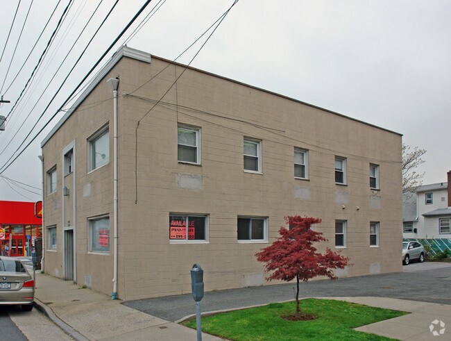
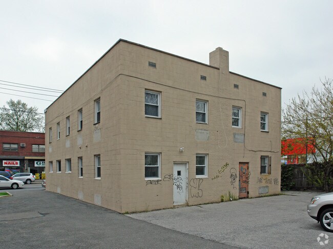
Property Record
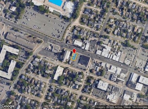
66 W Merrick Rd, Valley Stream, NY 11580
NEARBY LISTINGS FOR SALE OR LEASE
Property Detail
66 W Merrick Rd
2035-37-327-00-0343-0
343,345
Officebuilding
Nassau
X
New York
36059C0212G
343
2025
0.11 AC
2025
Southern Nassau
410500
Long Island (New York)
6,519 SF
Nassau County-Suffolk County, NY
DEMOGRAPHICS near 66 W Merrick Rd
1 Mile
3 Mile
5 Mile
2024 Total Population
29,970
261,122
679,278
2029 Population
29,128
250,657
647,417
Pop Growth 2024-2029
(2.81%)
(4.01%)
(4.69%)
Average Age
41
41
41
2024 Total Households
9,418
82,326
212,851
HH Growth 2024-2029
(2.95%)
(4.20%)
(4.88%)
Median Household Inc
$114,410
$117,742
$104,751
Avg Household Size
3.10
3.10
3.10
2024 Avg HH Vehicles
2.00
2.00
2.00
Median Home Value
$575,834
$638,756
$653,863
Median Year Built
1949
1952
1951
Nearby Places
- Restaurants
- Banks
- Shops
- Fitness
- Groceries
PUBLIC TRANSPORTATION
TRANSIT/SUBWAY
Valley Stream Station (Far Rockaway Branch - Long Island Rail Road, Long Beach Branch - Long Island Rail Road, West Hempstead Branch - Long Island Rail Road)
DRIVE
WALK
Distance
Valley Stream Station (Far Rockaway Branch - Long Island Rail Road, Long Beach Branch - Long Island Rail Road, West Hempstead Branch - Long Island Rail Road)
2 min
9 min
0.5 mi
COMMUTER RAIL
Valley Stream Station (Far Rockaway Branch - Long Island Rail Road, Long Beach Branch - Long Island Rail Road, West Hempstead Branch - Long Island Rail Road)
DRIVE
WALK
Distance
Valley Stream Station (Far Rockaway Branch - Long Island Rail Road, Long Beach Branch - Long Island Rail Road, West Hempstead Branch - Long Island Rail Road)
2 min
9 min
0.5 mi
Westwood Station (West Hempstead Branch - Long Island Rail Road)
DRIVE
WALK
Distance
Westwood Station (West Hempstead Branch - Long Island Rail Road)
3 min
1.3 mi
AIRPORT
John F Kennedy International
DRIVE
WALK
Distance
John F Kennedy International
13 min
7.4 mi
LaGuardia
DRIVE
WALK
Distance
LaGuardia
23 min
14.4 mi
Newark Liberty International
DRIVE
WALK
Distance
Newark Liberty International
50 min
34.1 mi
Freight Ports
NY - Red Hook Container Terminal
DRIVE
WALK
Distance
NY - Red Hook Container Terminal
34 min
18.8 mi
Nearby Properties
Address
Land Use
TOTAL SIZE
Lot Size
Zoning
Address
Land Use
TOTAL SIZE
Lot Size
Zoning
285,170 SF
12.63 AC
R3-1
Address
Land Use
TOTAL SIZE
Lot Size
Zoning
27.23 AC
PARK
Address
Land Use
TOTAL SIZE
Lot Size
Zoning
129,378 SF
4.86 AC
R2A
Address
Land Use
TOTAL SIZE
Lot Size
Zoning
64,618 SF
8.04 AC
Address
Land Use
TOTAL SIZE
Lot Size
Zoning
93.35 AC
PARK
Address
Land Use
TOTAL SIZE
Lot Size
Zoning
122,080 SF
2.81 AC
R2
Address
Land Use
TOTAL SIZE
Lot Size
Zoning
5,296 SF
37.42 AC
PARK
Address
Land Use
TOTAL SIZE
Lot Size
Zoning
213,338 SF
2.91 AC
R3X
Address
Land Use
TOTAL SIZE
Lot Size
Zoning
97,190 SF
1.75 AC
R3X
Address
Land Use
TOTAL SIZE
Lot Size
Zoning
78,380 SF
0.85 AC
R3-2
Address
Land Use
TOTAL SIZE
Lot Size
Zoning
806 SF
84.15 AC
R2A
Address
Land Use
TOTAL SIZE
Lot Size
Zoning
260,000 SF
4.14 AC
R2
Address
Land Use
TOTAL SIZE
Lot Size
Zoning
85,330 SF
2.91 AC
R3-2
Address
Land Use
TOTAL SIZE
Lot Size
Zoning
4,000 SF
23.88 AC
PARK
Address
Land Use
TOTAL SIZE
Lot Size
Zoning
131,000 SF
2.43 AC
M1-1
Address
Land Use
TOTAL SIZE
Lot Size
Zoning
59,963 SF
1.55 AC
M1-1
Address
Land Use
TOTAL SIZE
Lot Size
Zoning
53,100 SF
1.38 AC
R2
Address
Land Use
TOTAL SIZE
Lot Size
Zoning
73,300 SF
1.93 AC
R2
Address
Land Use
TOTAL SIZE
Lot Size
Zoning
55,392 SF
1.71 AC
R3-1
Address
Land Use
TOTAL SIZE
Lot Size
Zoning
41,712 SF
0.51 AC
R2A
Address
Land Use
TOTAL SIZE
Lot Size
Zoning
108,350 SF
4.88 AC
R3-2
Address
Land Use
TOTAL SIZE
Lot Size
Zoning
79,200 SF
2.30 AC
R2A
Address
Land Use
TOTAL SIZE
Lot Size
Zoning
1,677 SF
20.49 AC
R2A
Address
Land Use
TOTAL SIZE
Lot Size
Zoning
1,594 SF
1.01 AC
R2A
Address
Land Use
TOTAL SIZE
Lot Size
Zoning
45,434 SF
0.75 AC
R3X
Address
Land Use
TOTAL SIZE
Lot Size
Zoning
54,000 SF
1.06 AC
M1-1
Address
Land Use
TOTAL SIZE
Lot Size
Zoning
67,400 SF
1.84 AC
M1-1
Address
Land Use
TOTAL SIZE
Lot Size
Zoning
2,634,357 SF
57.63 AC
Address
Land Use
TOTAL SIZE
Lot Size
Zoning
28.12 AC
R3-2
Address
Land Use
TOTAL SIZE
Lot Size
Zoning
10,405 SF
4.97 AC
R3-1
The World's #1 Commercial Real Estate Marketplace
Connect with us
© 2025 CoStar Group
The information above has been obtained from sources believed reliable. While we do not doubt its accuracy we have not verified it and make no guarantee, warranty or representation about it. It is your responsibility to independently confirm its accuracy and completeness. Any projections, opinions, assumptions, or estimates used are for example only and do not represent the current or future performance of the property. The value of this transaction to you depends on tax and other factors which should be evaluated by your tax, financial, and legal advisors. You and your advisors should conduct a careful, independent investigation of the property to determine to your satisfaction the suitability of the property for your needs.